
“Bidenland” is a term coined by Brandon
Finnigan of the Decision Desk HQ website to describe a region of small,
blue-collar cities in east-central and northeastern Pennsylvania. It is less urbanized than the Philadelphia
metro area to its south, but more urbanized than central Pennsylvania to its
west. It tends to be evenly divided
between the two parties.
The Blue Mountain line
divides Bidenland into two regions: the anthracite coal region, from the city
of Scranton (birthplace of the former vice president) southwestward to
Northumberland and far northern Dauphin counties, and a string of counties to
the south and east of the coal region, from Reading through the Lehigh Valley
to the Poconos, that have become exurbs of Philadelphia and New York.
Anthracite coal, which gives the coal
region its name, is the hardest and purest form of coal, being over 90% carbon,
and almost all of America’s anthracite reserves are in this part of
Pennsylvania. (Other coal-mining areas
produce bituminous coal, which is 80-90% carbon.) The heyday of coal mining in this area was in
the late 1800s and early 1900s, coinciding with the great wave of immigration
from southern and eastern Europe. This
gave the area a high concentration of “ethnic” white residents; for example,
Luzerne (loo-ZERN) County is the only county in the country where Polish is the
most common ancestry, and Schuylkill (SKOOK’ll) County has one of the highest
concentrations of Lithuanian-Americans in the country. Unfortunately, the coal industry declined
after World War II, and the area has struggled to find a role in the
post-industrial economy.
The coal region can be usefully divided
into two sub-regions. The first is the Wyoming Valley, consisting of
Lackawanna (LOCK-a-WAHN-a), Wyoming, and northern and central Luzerne
Counties. The Wyoming* Valley is
centered around the cities of Scranton and Wilkes-Barre. In 1900, this area was second only to
Philadelphia and Pittsburgh as a population center in Pennsylvania but has lost
ground as the coal industry declined.
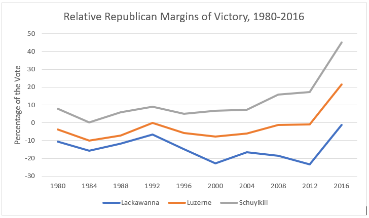
Lackawanna County, which contains Scranton, is a Democratic stronghold,
voting Republican for President only in the landslides of 1956, 1972, and
1984. Scranton is the base of the Casey
family (Bob Sr., who was governor from 1987-95, and Bob Jr., who has been U.S.
Senator since 2007) and of William Scranton, a governor in the 1960s who led
the moderate opposition to Barry Goldwater at the 1964 Republican
convention. Scranton politicians might
have been even more successful if Ernie Preate and Kathleen Kane, two popular
state attorneys general from the city, hadn’t ensnared themselves in scandal
before they could seek higher office.
The second part of the coal region consists
of Schuylkill County and surrounding parts of nearby counties (including the
communities of Hazleton, Shamokin, and Berwick); call it Greater Schuylkill
County. It is more rural, and
therefore more conservative, than the Wyoming Valley, but it still had a number
of Democratic strongholds until the rise of Donald Trump, who gained more votes
(in percentage terms) compared to Mitt Romney in Schuylkill County than any
other Pennsylvania county. The most
prominent recent politician from the area, Lou Barletta, was a former mayor of
Hazleton and Congressman whose blue-collar persona and staunch opposition to
illegal immigration presaged Trump, but who was unable to replicate his success
in a 2018 challenge to Senator Casey.
Another prominent politician from the area is Tim Holden, a moderate
Democrat who served in Congress for twenty years but lost a primary after his
district was redrawn to include more liberal parts of Bidenland. Lest you feel too sorry for them, Barletta is
now a lobbyist for Italian food merchants and Holden is on the state Liquor
Control Board, both of which sound a lot more fun than serving in Congress,
especially if free samples are involved.
The most heavily populated
part of Bidenland- in fact, the most populous metropolitan area in the state
outside Philadelphia and Pittsburgh- is the Lehigh Valley, consisting of
Lehigh, Northampton, and southern Carbon counties and centered around the
cities of Allentown and Bethlehem. In
many ways, it is a microcosm of the state as a whole, with declining industrial
areas (just ask Billy Joel), growing urban and suburban areas, a burgeoning
Hispanic and Middle Eastern population, and conservative rural areas in close
proximity to each other. Traditionally,
Lehigh County (which contains Allentown and part of Bethlehem) was Republican,
while Northampton County (which contains Easton and most of Bethlehem) was
Democratic. More recently, they have
begun to switch places, with Lehigh becoming more Democratic and Northampton
flipping to Donald Trump in 2016.
The area’s provincialism
(another trait, I’ll admit, that it shares with the state as a whole) means
that its politicians usually get outvoted by competitors from Philadelphia or
Pittsburgh when running for statewide office.
The most successful Lehigh Valley politician of recent years is the
exception that proves the rule. Pat
Toomey**, then the area’s congressman, challenged and nearly defeated
then-Senator Arlen Specter in the 2004 Republican primary, by which time the
state’s Republican base had grown so frustrated with Specter’s moderation that
they would have embraced any viable challenger, whether he came from Allentown
or Outer Mongolia. Toomey’s preparations
for a rematch drove Specter to switch parties, leaving him as the only
Republican standing in time for the 2010 wave.
Toomey’s appeal, at least initially, was more ideological than
geographic.
The northeastern corner of
Pennsylvania- Wayne, Pike, and Monroe counties- is the Poconos. A rural backwater for most of its history,
the area’s population quadrupled from about 70,000 in 1950 to about 280,000 in
2010 as it developed its tourist industry and ties to New York City and New
Jersey. Like most of rural Pennsylvania,
it was once solidly Republican (Wayne County was one of only four Pennsylvania
counties to stick with Barry Goldwater in 1964). In the 1990s and 2000s, Monroe County went
Republican by increasingly small margins (George W. Bush carried it by only
four votes in 2004) before going for Barack Obama handily in 2008. Pike and Wayne counties, while still red,
were closer than before. By 2016,
though, Pike and Wayne counties cast over sixty percent of their vote for
Donald Trump, while Hillary Clinton carried Monroe County by less than a
percentage point.
Political and Demographic Trends


Two broad conclusions stand out from this chart. First, Bidenland is usually a bellwether. In the years covered, it was within five percent of the national popular vote with only two exceptions: 1964 and 2016. Second, until recently, the coal region was reliably more Democratic than the exurbs. This changed in 2008, when Obama did better in the exurbs than in the coal region, and even more dramatically in 2016, when Trump carried the coal region handily. Let’s take a closer look at how individual counties voted, beginning with the four largest exurban counties:


*The state of Wyoming gets its name from this area, indirectly. A poem (“The frontier maid, or A tale of Wyoming”) was written about conflict between Indians and settlers in this area during the American Revolution and was popular at the time the Wyoming Territory was established, inspiring the name.
**In the interest of full disclosure, I worked on Senator Toomey’s official staff from 2011-13.
No comments:
Post a Comment