 |
| Via Wikipedia, a map of Pennsylvania with counties labeled. |
Greetings from the center of Presidential
politics, rural Pennsylvania.
Most political observers know that Donald
Trump was the first Republican since 1988 to carry the Keystone State, but fewer
realize that Trump’s victory broke an even longer-standing pattern. Pennsylvania was once one of the most
Republican states in the Union, voting for the GOP in every election between
the Civil War and New Deal (except 1912, when it went for Theodore Roosevelt’s
third-party bid), even sticking with Herbert Hoover in 1932. Franklin Roosevelt carried the state the
other three times he ran, but by smaller margins than he won the national
popular vote, and Pennsylvania went for Thomas Dewey over Harry Truman in 1948. In 1952, however, Pennsylvania began a
pattern of being slightly more Democratic than the nation as a whole and stuck
to it until 2012.

(The source for this data and all other election data in this series is Dave Leip's Atlas of U.S. Presidential Elections at https://uselectionatlas.org/.)
As you can see, in every election from 1952
until 2012, Pennsylvania was more Democratic than the national popular vote,
but by six percentage points or less in every year except the 1964 and 1984
landslides. The 2016 election broke this
pattern, as Donald Trump carried Pennsylvania while losing the popular vote
nationwide.
This consistency masked a number of changes
going on within the state. Western
Pennsylvania, once heavily Democratic, became solidly Republican outside the
city of Pittsburgh. The Philadelphia
suburbs, once a Republican stronghold, have become more Democratic. In the central part of the state, Republicans
have increased their margins in rural areas while losing ground in some cities,
such as State College, Harrisburg, and Lancaster. A number of more blue-collar cities, such as
Erie and Scranton, seemed to be getting more Democratic, but swung toward
Donald Trump in 2016.
Pennsylvania Regions

The most fundamental division in
Pennsylvania’s geography runs along the Blue Mountain, at the eastern edge of
the Appalachians. It crosses the
Mason-Dixon line almost halfway across the state’s southern border, near
Chambersburg, then runs north of Carlisle, Harrisburg, Lebanon, Reading, and
Allentown, roughly following the path of Interstates 81 and 78. Pike and Monroe counties, in the Poconos, are
north of the Blue Mountain, but their proximity to the New York metropolitan
area makes their demographics more aligned with the area to their south.
The area south and east of the Blue
Mountain is mostly part of the Piedmont, the area of rolling hills stretching
from New York City to Alabama. It tends
to align with the Northeastern cities, mostly with Philadelphia, but in some
areas with New York or the Baltimore-Washington region. Outside of already densely packed
Philadelphia and some of its suburbs, its population has grown at an impressive
rate for a northern state. It is
relatively affluent. Politically, it has
shifted to the Democrats (especially in the areas around Harrisburg, Lancaster,
and the Philadelphia suburbs), but Republican margins have been holding, or
even increasing, in the areas around York and Reading (rhymes with “wedding”).
The area north and west of the Blue
Mountain is the stereotypical Pennsylvania of coal mines and steel mills. It tends to identify with the Midwest or
Appalachia. It is not as wealthy as
south-central or southeastern Pennsylvania, and, outside of State College and
some of the Pittsburgh suburbs, its population is either declining or growing
slowly. It is either part of the
Appalachian Mountains or the Allegheny Plateau, the easternmost part of the
Mississippi River basin. Politically,
the Democrats used to have a great deal of support here, but it began turning
toward the Republicans around the turn of the millennium (there are counties
here that voted for Walter Mondale, John McCain, and Mitt Romney), a trend
which has accelerated with the rise of Donald Trump.
 |
| Population growth by county, 2000-10 (Source: U.S. Census Bureau) |
 |
| Median household income by county, 2010 (Source: U.S. Census Bureau) |
Another way to split Pennsylvania is into
four basic regions, one entirely east of the Blue Mountain, one entirely west,
and two straddling it. These regions
are:
- Bidenland, a term coined by Brandon Finnigan of Decision Desk HQ. This region consists of several small, blue-collar cities (Reading, Allentown, Bethlehem, Scranton, and Wilkes-Barre) in northeastern and east-central Pennsylvania. The Blue Mountain divides it between the anthracite coal region, stretching from Scranton to Schuylkill County, and a string of exurban areas from Reading to the Poconos. It tends to be evenly divided in elections, but swung to Trump in 2016.
- Central PA, the area James Carville had in mind when he described Pennsylvania as “Philadelphia and Pittsburgh with Alabama in between”. This is the state’s Republican stronghold, and its presence is what keeps Pennsylvania in play for them. The Blue Mountain divides it between the growing area around Harrisburg, Lancaster, and York, and the more thinly populated Appalachian area.
- SEPA, or Philadelphia and its “collar counties” (Bucks, Chester, Delaware, and Montgomery). This is the smallest region by land area, but the largest by population. In the past, the Republican suburbs balanced the Democratic city, but recently, both have become Democratic strongholds. Since the mid-20th century, it has held steady at just under a third of the state’s population.
- Western PA, the most stereotypically “rust belt” region. It contains the Pittsburgh metro area, as well as Erie and several smaller, blue-collar cities such as Johnstown and New Castle. Once heavily Democratic, Republicans have made impressive gains here, but its shrinking population is making it less of an asset in statewide elections.
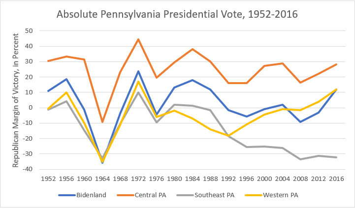
I’ll look at each of these regions in
detail, including the sub-regions and trends within each, in subsequent posts. For now, here is a look at how the four
regions voted, both in absolute terms and relative to the national popular vote,
showing the trends I’ve mentioned above:

Below is the population of each region,
both in absolute terms and as a percentage of the state:


As you can see, Bidenland declined slightly
before growing again, as the suburban areas around Reading, the Lehigh Valley,
and the Poconos grew, while the southeast has been fairly steady at just under
one-third of the state’s population.
Central Pennsylvania has grown steadily, while Western Pennsylvania has
declined.
No comments:
Post a Comment