
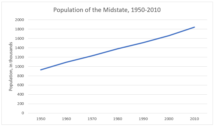
Like Bidenland, Central Pennsylvania is split in two by the Blue Mountain. To the south is the area around Harrisburg, Lancaster, York, and several smaller cities such as Chambersburg and Lebanon. The area shares the Harrisburg media market and (along with some counties to its west) the 717 area code. It still retains its Pennsylvania Dutch* heritage and rural character, although it has become increasingly suburbanized and diverse in recent years. It became the backbone of the state Republican party as its population grew (from around 900,000 in 1950 to over 1.8 million by 2010) and as the GOP lost ground in the Philadelphia suburbs, but Democrats have made some inroads here in the past few elections. The local press refers to it as “central Pennsylvania” (although it’s a bit south and east of center), “the Susquehanna Valley” (which isn’t a valley), or “the Midstate”.
Politically, the Midstate can be divided into three areas. The first is the urban islands of Harrisburg, Lancaster, and York. These cities are, of course, more densely populated than the surrounding suburban and rural areas. They have long been more Democratic than their surroundings, but the bottom has fallen out for Republicans here in recent cycles:

The cities are much more diverse than the surrounding areas. Harrisburg is just over fifty percent black, and Lancaster and York are just over fifty percent white, with large Hispanic and black populations. Until recently, Lancaster was one of the top cities of its size in the country for refugee resettlement.
The suburban areas of central Pennsylvania were once some of the most Republican territory in the state. In recent cycles, though, an area stretching from the Lancaster suburbs, through the Hershey and Harrisburg area, into Cumberland County as far as Carlisle, as well as some suburban areas around York, has become friendlier to the Democrats. Barack Obama did well here in 2008, and while Mitt Romney and Donald Trump gained back some of the GOP’s losses, they still didn’t match Republican margins of the 1980s and 1990s. The perfect storm may have come in Governor Tom Wolf’s re-election in 2018. Wolf, a Democrat, was a popular incumbent from York County in a state that usually re-elects its governors and ran during a Democratic wave year. Wolf received fifty-nine percent of the vote in Dauphin County, carried Cumberland County outright, and came within about 6,200 votes (out of around 200,000 cast) of carrying Lancaster County. Keep in mind, though, that Wolf was re-elected by a 57-40% margin, which is unlikely to be repeated in a Presidential election. These areas aren’t blue yet, or even (outside of a few inner suburbs) purple, but you can consider them the Blue-Curious Midstate.
 |
| Actually, the Amish themselves (at least the ones who vote) are still solidly Republican, but I couldn't resist. |
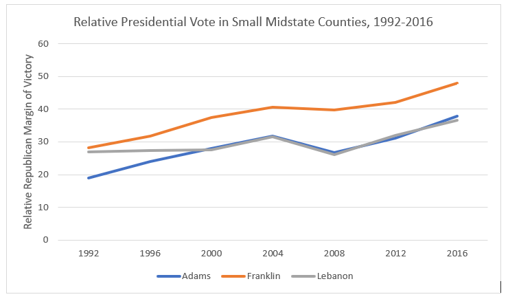
The more rural areas, and some outlying suburbs, in the Midstate are as staunchly Republican as ever. This area, Amish Paradise, includes most of Lebanon and York counties, eastern and southern Lancaster County, western Cumberland County, and all of Adams and Franklin counties. In future cycles, as the Harrisburg and Lancaster areas expand or the Philadelphia and Baltimore-Washington areas encroach on the region, Democrats might start to make inroads here, but it hasn’t shown up in the election returns here yet.
The parts of central Pennsylvania north and west of the Blue Mountain form Pennsylvania’s part of Appalachia. The southern Appalachians stretch from the Mason-Dixon line to State College and Interstate 80. They have always been thinly populated, due to mountainous terrain and a lack of coal reserves compared to northeastern and western Pennsylvania, but some settlements have prospered along transportation links through the region. Lewistown and Altoona grew in the nineteenth and early twentieth centuries along the main canal and railroad link through the state, and more recently, growth has been concentrated along the Pennsylvania Turnpike and the highways leading north from Harrisburg. The area has a mixed Scots-Irish and Pennsylvania Dutch heritage. Some counties here, particularly Mifflin, Juniata, and Fulton, were Democratic strongholds before the New Deal (and occasionally afterward), but the area is now solidly conservative and Republican.
Centre County, the home of Penn State University, is more popularly known as Happy Valley. Like university towns across the country, it has become increasingly friendly toward the Democrats in recent elections. Its population is also growing faster than surrounding areas, so it may become more important for statewide Democrats in upcoming elections.
The area just to the east of Happy Valley is, in some ways, its smaller, less intense version: the Mildly Amused Valley. Most of its population is in Union and Snyder counties, the only Pennsylvania counties not to have voted for any Democratic Presidential candidate since the Civil War. However, Union County is the home of Bucknell University; Bucknell, much smaller than Penn State, is not big enough to turn Union County blue, but Republican margins here have plateaued while expanding elsewhere in Appalachia. Combined with the Geisinger (GUY-singer) Health System in nearby Montour County (which has a population of only 18,000, so any major employer will have a lot of impact), the area has some of the “eds and meds” economy more common in larger university towns.
Finally, the area north of Interstate 80 and State College is the Northern Tier of Pennsylvania. Like the areas further south, it is mountainous and thinly populated. Its largest city is Williamsport, best known as the home of the Little League World Series. Many of the region’s early settlers came from New England, as the area is due west of Connecticut and Rhode Island. Economically, its heyday came with the rise of the timber industry in the late nineteenth century, but more recently, fracking and the natural gas industry have led to growth in the region. It has long been solidly Republican, and became even more so with the rise of Trump.
Traditionally, central Pennsylvania politicians did not do well in statewide elections. The area does not have the population base of Philadelphia or Pittsburgh, and politically, Republicans took it for granted while Democrats didn’t have much hope for this region. An ambitious central Pennsylvania politician would have been better advised to run for the General Assembly (like longtime president pro tem of the state Senate, Robert Jubelirer of Altoona, or current state Senate Majority Leader Jake Corman, of Centre County) or the U.S. House (like former Reps. Bud Shuster of Altoona, who chaired the Transportation Committee and became famous, or infamous, for directing pork to his district, or Bob Walker of Lancaster County, who became one of Newt Gingrich’s top lieutenants), rather than seek statewide office.
This might be changing, as the current governor, Tom Wolf, is from York County. His path to the governorship, though, was unusual. He had never been elected to, or even run for, public office before the 2014 race for governor, although he had served in former Gov. Ed Rendell’s cabinet. In the primary, he had the advantages of being able to self-fund from his family business, and of facing three candidates from suburban Philadelphia who split that area’s vote. In the general election, he faced an unpopular incumbent, Tom Corbett, who became the first incumbent governor to lose re-election since Pennsylvania governors were allowed to run for second terms in 1967. Nevertheless, Tom Wolf’s success might be a sign of the future, as Central Pennsylvania’s population grows and as the area becomes more competitive politically.
Political and Demographic Trends


The four largest counties of the Midstate all clearly shifted to the Democrats between the 2004 and 2008 Presidential elections. (In fact, Lancaster County had the biggest improvement for Barack Obama over John Kerry of any county in Pennsylvania.) However, that shift has not continued in 2012 and 2016. There was a slight trend toward the Democrats in Cumberland County, but they plateaued in Dauphin and Lancaster counties, and York County is as Republican-leaning as ever. The Midstate isn’t as Republican as it used to be, but it would be premature to say it will necessarily become Democratic, or even a swing area, particularly since the smaller counties don’t show any signs of moderating:
Appalachia,
outside of the Happy and Mildly Amused Valleys, has been getting even more
solidly Republican. To simplify these
graphs, I’m combining Bedford, Blair, Fulton, Huntingdon, Juniata, Mifflin,
Perry, and Somerset counties into the Southern Appalachians; Bradford, Cameron,
Lycoming, McKean, Potter, Sullivan, Susquehanna, and Tioga counties into the
Northern Tier; Montour, Snyder, and Union counties into the Mildly Amused
Valley; and making Centre County its own entity.


However,
there is a silver lining for Democrats.
The population of Appalachia has been growing in recent decades, but
most of that growth has been in the areas more favorable to them:

For
its part, the Midstate’s population has been growing steadily, almost doubling
between 1950 and 2010:
*The Pennsylvania Dutch are actually German. There are two theories about how they got misnamed. One is that English colonists misunderstood deutsch (or in their dialect, deitsch) as “Dutch”; the other is that the term “Dutch”, at the time, included much of German-speaking Europe as well as the Netherlands.
No comments:
Post a Comment