Wednesday, October 30, 2019

Pennsylvania Political Geography, VI: Further Down the Ballot


So far, this series has largely focused on Presidential elections, but Pennsylvania has played a crucial role in the 2016 Senate elections and the 2018 midterms. 

In 2016, Pennsylvania was crucial to Republican hopes in the Senate, as well as the White House.  Incumbent Sen. Pat Toomey fended off Democratic challenger Katie McGinty, a former official in the Rendell and Wolf administrations, doing slightly better than Donald Trump.  Toomey carried the state by about 86,000 votes, as opposed to Trump’s 44,000 votes.  Toomey had a more traditional path to victory for a Pennsylvania Republican, outdoing Trump in the Philadelphia suburbs, Reading, the Midstate, the Lehigh Valley, and Pittsburgh.  Four counties- Bucks, Centre, Chester, and Dauphin- voted for Toomey but not Trump.  However, he was unable to match Trump’s numbers across rural northern and western Pennsylvania, especially in traditionally Democratic parts of the anthracite coal region and Murthaland.  Toomey’s victory suggests an alternative path for Republicans: they don’t have to match Trump’s rock-star numbers in rural areas if they regain some of their support in the suburbs.


Governor Tom Wolf, whose defeat of incumbent governor Tom Corbett was one of Democrats’ few bright spots in 2014, was initially thought to be vulnerable in 2018- after all, he was the only Democratic governor running for re-election in a state Donald Trump carried.  However, he easily prevailed over then-state Sen. Scott Wagner, a fellow York County resident, for a second term.

Two patterns stand out from these maps.  The first is how much more polarized the 2018 election was than the 2014 election.  Even though state-level elections are usually less polarized than national ones- Kansas, Louisiana, and Montana have Democratic governors, while Maryland, Massachusetts, and Vermont have Republican ones- Wolf followed a pattern common to Democrats across the country, gaining ground in urban and suburban areas while losing ground in rural ones.  Wolf beat Wagner by a larger margin than Corbett (57-40% as opposed to 55-45%),  but he only flipped one Corbett county while Wagner took eight that voted for Wolf the first time.  The second is that Democrats improved in key areas of the state.  Wolf improved throughout the Midstate, in the Bidenland exurbs, and in the counties surrounding Pittsburgh, more than offsetting his declines in rural western Pennsylvania and the anthracite coal region.  It remains to be seen whether this is the result of Wolf’s personal popularity and the usual turn against the President’s party in midterms, or if it’s a permanent shift in voting patterns.  If the latter, Democrats have reason to be optimistic about Pennsylvania turning blue again with a new coalition.


Comparing Senator Casey’s 2018 victory with his initial election in 2006 shows even more drastic changes.  Although Casey won by only a slightly smaller margin last year (56-43%, as opposed to 59-41% in 2006), he went from carrying thirty-four counties to carrying fourteen.  When Casey was first elected to the Senate, he had a strong personal brand (inherited from his father) that played well in ancestrally Democratic areas in Bidenland and western Pennsylvania, but his coalition now looks much more like a generic Democrat’s.


I began this series by noting that Donald Trump’s victory in Pennsylvania broke a sixty-year-old pattern of Pennsylvania being slightly more Democratic in Presidential elections than the country as a whole.  I’ll end by noting an even longer, and more subtle, pattern in Pennsylvania politics that has only recently been broken.  In 1896, Boies Penrose, of Philadelphia, replaced J. Donald Cameron, of Harrisburg, as a U.S. Senator from Pennsylvania.  This began 118 years of Pennsylvania’s governor and/or at least one of its senators coming from either Philadelphia, one of the four suburban counties, or Allegheny County, which ended when Tom Wolf, of York County, defeated Tom Corbett, of Allegheny County, for governor in 2014.  As recently as 2006, all three offices were held by someone from the Philadelphia or Pittsburgh areas: Gov. Ed Rendell and Sen. Arlen Specter were from Philadelphia, and Sen. Rick Santorum was from Allegheny County.  That year, Bob Casey Jr., of Scranton, replaced Santorum, and in 2010, Pat Toomey, of Allentown, replaced Specter. 


The urban areas could make a comeback in 2022, when Gov. Wolf will be term-limited and Sen. Toomey will be up for re-election.  (It’s unclear whether Toomey will seek a third term; he has supported limiting senators to two terms, and followed a similar pledge when he was in the House.)  Lt. Gov. John Fetterman, of Allegheny County, ran for the Senate in 2016, coming in third in the Democratic primary, and is believed to be interested in running again; Attorney General Josh Shapiro, also a Democrat, of Montgomery County, is believed to be interested in running for governor.  The 2018 elections gave the Democrats a bumper crop of new House members from suburban Philadelphia and Pittsburgh (Chrissy Houlahan, Madeleine Dean, Mary Gay Scanlon, and Conor Lamb, from Chester, Montgomery, Delaware, and Allegheny counties, respectively), who might seek higher office.


Of course, if a Democrat is elected President in 2020, the 2022 midterms could favor Republicans (repeating the pattern of 1994 and 2010).  GOP candidates to restore the big cities’ representation include state House Speaker Mike Turzai, of Allegheny County, who has been interested in running for governor before; U.S. Rep. Brian Fitzpatrick, of Bucks County, who has held a swing congressional district, but who might be too moderate to win a statewide primary; and Jeff Bartos, a Montgomery County businessman who ran for lieutenant governor under Scott Wagner, and who is one of the few Pennsylvania Republicans whose reputation was strengthened after 2018.  The bench for Republicans in these areas is significantly thinner than the bench for Democrats.  As the partisan gap between rural and urban areas widens, in Pennsylvania as throughout the country, future elections will likely feature Republicans from rural areas and small cities trying to gain traction in the metropolitan areas, while Democrats from the cities and suburbs try to keep down Republican margins in rural areas.


Monday, October 28, 2019

Pennsylvania Political Geography, V: Western Pennsylvania


Finally, we come to western Pennsylvania, the home of Pennsylvania’s second-largest city, Pittsburgh, as well as a number of smaller cities (such as Erie, Johnstown, and New Castle) and suburban and rural areas.  Although it has steadily lost population since the 1960s, its stark turn to the Republicans has been a defining feature of Pennsylvania politics since the turn of the millennium.


Setting aside Pittsburgh for now, the most defining feature of western Pennsylvania might be its old industrial and coal mining towns and small cities.  This area wraps and winds throughout the area.  Johnstown might be its most iconic city and is the home of its namesake, longtime Congressman John Murtha.  From there, Murthaland goes northward throughout Cambria County into Elk County, a German Catholic stronghold, and Clinton County, and west into Indiana, Armstrong, and northern Westmoreland counties.  It includes Fayette and Greene counties in the state’s southwest corner and goes from there northward into the Monongahela (or, as locals call it, the “Mon”) and Beaver valleys.  Murthaland stretches as far north as the cities of New Castle and Sharon, directly across the Ohio border from Youngstown.  


While Congressman Murtha first came to national attention in 2005 and 2006, when he became one of the leading members of Congress opposing the war in Iraq (a stance given more credibility because of his service as a Marine in Vietnam), he had been a fixture in western Pennsylvania politics since being elected to Congress in 1974.  He had risen to prominence in setting defense policy, a position he used to steer as much spending as he could to his district, and had survived several rounds of redistricting while the area’s chronic population loss meant its districts were frequently chopped up.  By 2001, the Republican state legislature’s desire to preserve Murtha’s clout while making surrounding districts friendlier to Republicans led them to pack his district with as many Democratic-leaning industrial towns as they could, creating a gerrymander that wrapped from the southwest corner and Mon Valley to Johnstown, then doubled back, plucking the towns of Indiana and Latrobe from their surroundings, before ending in the northeastern corner of Allegheny County.

By this time, though, the fundamentals of Murthaland were changing.  Although Murtha never had any trouble being re-elected before his death in February 2010, and his chief of staff, Mark Critz, held the district in the 2010 tea party wave, the Twelfth District was the only district in the country that voted for both John Kerry in 2004 and John McCain in 2008.  (Perhaps it just really likes Vietnam veterans named John.)  Even before the 2010 wave, Republicans began making inroads in the area’s state legislative delegation. 


The more rural areas of northwestern Pennsylvania, as well as some of the suburbs of Pittsburgh, were Republican strongholds even when western Pennsylvania was heavily Democratic: you might call them Hipster Republicans.  Northwestern Pennsylvania was America’s first oil patch; it was here that the first modern oil well was dug around the time of the Civil War, and that Standard Oil got its start.  The area still produces some oil, but has been eclipsed by the Great Plains, Gulf Coast, and Alaska.  Politically, they’re joined by much of the Allegheny County suburbs around Pittsburgh, as well as parts of neighboring Washington and Westmoreland counties.  Butler County, where Rick Santorum grew up and where current Congressman Mike Kelly has his base, acts as a bridge between the two areas.  Suburban Pittsburgh has traditionally been a strong base for statewide elected Republicans.  The last four Republicans elected governor were from western Pennsylvania.  Two of them (Richard Thornburgh, who served from 1979-87, and Tom Corbett, who served from 2011-15) came from Allegheny County, as did Senator John Heinz, who served from 1977 until his death in plane crash in 1991.  Heinz won his 1988 re-election effort by a 66-32% margin, the biggest landslide for a Pennsylvania Republican in modern times, and carried every county in western Pennsylvania even as Michael Dukakis won the region.


As with affluent suburban areas throughout the country, though, Democrats are making inroads into suburban Pittsburgh, particularly in northern and south-central Allegheny County, spilling into part of southern Butler County.  This came to the nation’s attention, when, after near-misses in Wichita, the entire state of Montana, rural South Carolina, and the Atlanta suburbs, they won a special election for a Republican-held house seat here in March 2018.  In honor of the winner, Conor Lamb, who won the general election last year (in a reconfigured district due to a court order), I’m calling this area Lamb’s Chop.  It has only recently begun trending toward the Democrats, but another special election here, in April 2019, put Democrats in striking distance of taking over the state Senate in 2020.  Both the top Republican in the state House, Speaker Mike Turzai (TER-zigh), and its biggest conservative firebrand, Daryl Metcalf, have districts here, complicating their political futures.  (For what it’s worth, the top Democrat in the state House, Frank Dermody, represents a Murthaland district in northeastern Allegheny County that’s trending Republican.)


The city of Pittsburgh itself, as well as several smaller, minority-dominated communities to its east and northwest, are as liberal and Democratic as ever, to the extent that democratic socialists have made inroads in local politics.  In honor of the most prominent of them, John Fetterman, who parlayed media attention as the mayor of Braddock, a small mill town, into the lieutenant governorship in 2018, I’m calling the area the Yinz* Democratic Republic of Fettermania.  During the 1970s and 1980s, it was not unusual for a Republican candidate to carry Allegheny County while losing some of the surrounding counties; since 2000, Allegheny has become clearly the most Democratic county in this part of the state.  Pittsburgh, like Philadelphia, was strongly Republican between the Civil War and the New Deal, began voting Democratic under Franklin Roosevelt, and saw Democrats take over local government shortly afterward.  Allegheny County Democrats have had less success than their Republican neighbors in winning statewide; after David Lawrence, a former mayor of Pittsburgh who served as governor from 1959-63, none has been elected governor or U.S. senator. 


The most nationally known political figure from Allegheny County in recent years is Pennsylvania’s former senator, Rick Santorum.  Santorum first ran for Congress in a district combining suburban and industrial areas in 1990, upsetting Democratic incumbent Doug Walgren.  The district was reconfigured to have a three-to-one Democratic majority in 1991, but Santorum was still re-elected handily, in part because a clown-car primary produced a weak Democratic opponent.  He was elected to the U.S. Senate in the Republican wave of 1994, served two terms, and was voted out in the Democratic wave of 2006.  His policies were a combination of staunch social conservatism and populist economic policies, such as a lukewarm attitude toward free trade and staunch opposition to illegal immigration.  Santorum’s career seemed to be over until 2012, when he ran as a populist alternative to Mitt Romney and carried eleven states in the Republican presidential primary.  In both Pennsylvania and presidential politics, Rick Santorum served as a forerunner to Donald Trump.  


Finally, Erie County sits at the northwest corner of the state, giving it access to the Great Lakes.  Erie is Pennsylvania’s fourth-largest city, behind only Philadelphia, Pittsburgh, and Allentown, and like many other Pennsylvania cities, it thrived during the industrial era and has struggled economically in recent decades.  Due to its isolation from other population centers- as the crow flies, Toronto is closer to Erie than Pittsburgh, and Detroit is closer than Philadelphia- it is best considered its own entity.  Like Scranton at the opposite end of northern Pennsylvania, Erie was Democratic-leaning, and didn’t show much sign of changing, until Donald Trump ran in 2016 and became the first Republican Presidential candidate since 1984 to carry Erie County.  Only one Erie County resident has ever held a major statewide office**: Tom Ridge, who served as governor from 1995-2001.  (Outside Pennsylvania, he is probably best known as the first Secretary of Homeland Security.)  Ridge, a pro-choice, moderate Republican who self-deprecatingly referred to himself as “the man nobody has heard of from the place nobody has been”, won the 1994 primary for governor over the more conservative Attorney General Ernie Preate, of Scranton, while Preate was caught up in scandal and a third candidate, then-state Sen. Mike Fisher, was splitting the conservative vote.  Ridge went on to win the general election amid that year’s Republican wave and a split between outgoing governor Bob Casey Sr., a pro-life Democrat, and the Democratic nominee, Lt. Gov. Mark Singel, over abortion.
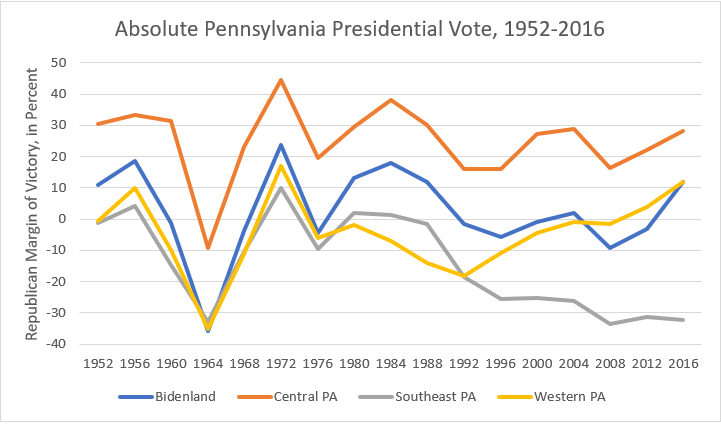
Western Pennsylvania Political and Demographic Trends


Moderate, working-class Democrats who occasionally vote Republican are often called “Reagan Democrats”.  However accurate that might be elsewhere, it’s not correct in western Pennsylvania, where Walter Mondale won handily in 1984.


For the purposes of these graphs, I consider Armstrong, Beaver, Cambria, Clinton, Elk, Fayette, Greene, Indiana, Lawrence, Mercer, Washington, and Westmoreland counties to be Murthaland, and Butler, Clarion, Clearfield, Crawford, Forest, Jefferson, Venango, and Warren counties to be the Hipster Republicans.  The recession of the early 1980s coincided with the collapse of the region’s steel industry, hurting Ronald Reagan’s re-election campaign in the area.  In Western Pennsylvania as a whole, Walter Mondale received about 860,000 votes to Reagan’s 750,000.  Even in the traditionally Republican counties, Reagan barely performed better than in the nationwide vote.  Since then, Republicans have surged in the area.  In 2004, Murthaland flipped from Al Gore to George W. Bush, and in 2012, Western Pennsylvania as a whole flipped from Barack Obama to Mitt Romney; neither has looked back.  The great irony of John Murtha’s career is that, just as he was becoming nationally known as an opponent of George W. Bush, his constituents were flocking to Bush’s party.

Allegheny County closely tracked Murthaland from the 1950s to the 1990s, but after 2000, as the partisan divide between urban and rural America deepened, the two areas diverged.  The graph also shows why Erie County’s vote for Donald Trump came as a surprise; before 2016, it had been reliably Democratic, with Barack Obama doing better there than he did in Allegheny County.  Elsewhere in western Pennsylvania, Trump merely accelerated existing trends.

To see how far the Democratic trend is spreading in the Pittsburgh suburbs, let’s look at Allegheny County and its neighbors.  In Butler County, traditionally the most Republican of the five, the Republicans appear to be leveling off as the other counties catch up to it.  Beaver, Washington, and Westmoreland counties, though, continue to move to the right of the national electorate.  It may be that, as these areas become less industrial and rural and more suburban, Democrats will have a revival here, but there’s no evidence of it in Presidential elections yet.

The most important demographic trend in western Pennsylvania is its steadily declining population.  Allegheny County peaked at about 1.6 million people in 1960 and is now just above 1.2 million.  Murthaland peaked later, in 1980, but has been falling since.  Erie County grew from 1950 to 1980, but has stagnated since then.  The only consistent demographic bright spot is Butler County, which almost doubled in population between 1950 and 2010, growing from about 97,000 people to 184,000.  In the mid-twentieth century, Western Pennsylvania was the most populous of Pennsylvania’s regions.  During the 1980s, Southeastern Pennsylvania passed it, and if current trends continue (with Central Pennsylvania gaining about 200,000 people per decade and Western Pennsylvania losing about 100,000), Central Pennsylvania will pass it sometime around 2040.
The city of Pittsburgh has lost over half its population since 1950.  The remainder of Allegheny County grew in the 1950s and 1960s due to the expansion of suburbs, but it has also declined since then, though not as rapidly as Pittsburgh.  Because of this, as a proportion of the county’s population, Pittsburgh has declined from forty-five percent in 1950 to about a quarter today.  The fact that Allegheny County is trending to the Democrats while Pittsburgh is shrinking suggests that the trend is mostly in the suburbs.


*The Pittsburgh colloquial plural of “you”.


**Raymond Shafer, from neighboring Crawford County, served as governor from 1967-71.

Thursday, October 24, 2019

Pennsylvania Political Geography, IV: Southeastern Pennsylvania


We come now to southeastern Pennsylvania, the state’s portion of the Northeastern megalopolis stretching from Washington to Boston.  Traditionally, it is defined as the city of Philadelphia (which, since the 1850s, has been the same thing as Philadelphia County) and the nearby counties of Bucks, Chester, Delaware, and Montgomery. About four million people live here (almost one-third of the state’s population), making it the most populous of Pennsylvania’s regions, but it is by far the smallest in land area.

Demographically and geographically, SEPA can be broken down into four areas:

·       The “Main Line” originally referred to the wealthy towns along the Pennsylvania Railroad immediately west of Philadelphia, from Lower Merion at the southern tip of Montgomery County, through northern Delaware County, into eastern and central Chester County.  I use the term Greater Main Line to describe affluent neighborhoods in and around Philadelphia, an area that includes central Bucks County, central and southern Montgomery County, most of Chester and Delaware counties, and much of Northwest (particularly Manayunk and Chestnut Hill) and Center City Philadelphia.  This is the most affluent and well-educated part of the state, and like affluent suburbs throughout the country, it has been getting more Democratic since the 1990s, a trend that accelerated with the rise of Donald Trump.  It is predominantly white but increasingly diverse.

·        There are some white working-class neighborhoods in and around Philadelphia that deserve mentioning.  I call them the 700 level, after the cheap seats at Veterans’ Stadium, the home of the Phillies and Eagles from 1971-2003, where much of the current sterling reputation of Philadelphia sports fans originated.  This area includes parts of southern Delaware County, particularly around Marcus Hook and Tinicum Township, south and northeast Philadelphia, and lower Bucks County.  Fishtown, the Philadelphia neighborhood Charles Murray used as a metonymy for white working-class areas throughout the country, is in this area (although, ironically, it’s starting to become gentrified).  These areas were trending Democratic during the 1990s and 2000s, but Republicans have become more successful here in recent years.  After Barack Obama carried all of Philadelphia’s sixty-six wards in 2008 and 2012, Donald Trump carried the sixty-sixth ward in Northeast Philadelphia and the twenty-sixth ward in South Philadelphia (another ward, the fifty-eighth in Northeast Philadelphia, split its ticket, voting for Pat Toomey and Hillary Clinton).

·        There are a number of minority strongholds in and around Philadelphia.  The city itself is majority-minority, with a population around forty percent black and fifteen percent Hispanic.  The city’s black population is concentrated in west and north Philadelphia, while its largest Hispanic neighborhood is in the near northeast.  There are other predominantly minority areas around the cities of Chester, Norristown, and Coatesville; eastern Delaware County; near Lincoln University, one of the nation’s oldest historically black colleges; and in areas of southern Chester County where the agricultural industry has attracted Mexican immigrants.  Like majority-minority areas throughout the country, these areas tend to vote Democratic.

·        Finally, there are a few rural redoubts left in the northern and western areas of Bucks, Montgomery, and Chester counties where the hilly terrain and distance from Philadelphia has inhibited settlement.  These areas are heavily Republican, even more so with Donald Trump on the ticket, but thinly populated.  They’ll probably see more development and population growth in the future, but as they do, their demographics will start to resemble the Greater Main Line.

Southeast Pennsylvania Political History and Trends

Philadelphia has always been the largest city in Pennsylvania, and as such, it has traditionally been a major center of power.  Between the Civil War and the New Deal, when Pennsylvania was a reliably Republican state, Philadelphia was under the control of a Republican machine.  Philadelphia voted for Franklin Roosevelt in 1936, 1940, and 1944, and for Harry Truman in 1948, but the Democrats did not seize control of the local government until 1951. That year, a home rule charter for the city took effect, and Joe Clark was elected the first Democratic mayor since 1884. The Democratic margin of victory in Philadelphia grew dramatically, from around 7,000 votes for Harry Truman in 1948 to 160,000 votes for Adlai Stevenson in 1952; in fact, if Philadelphia and the four collar counties were their own state, it would have flipped from Thomas Dewey to Stevenson.  Recall that 1952 was the year Pennsylvania began voting more Democratic than the rest of the nation in Presidential elections; the shift in Philadelphia is a major reason why

The careers of two prominent U.S. Senators can be considered the last hurrah of Philadelphia Republicans.  Hugh Scott, a Republican Congressman from northwest Philadelphia, was elected to the Senate in 1958, defying that year’s Democratic wave, and served until 1976, rising to Minority Leader.   Arlen Specter was elected in 1980 in an election that broke along regional lines.  Specter’s Democratic opponent was Pete Flaherty, a former mayor of Pittsburgh.  Most western Pennsylvania counties, even usually Republican ones, went for Flaherty, while the city of Philadelphia went for Specter, the last time it has voted Republican for a major office.


However, the suburbs remained staunchly Republican from the 1950s into the 1980s, particularly in Chester and Montgomery counties.  This, combined with a split among city Democrats between blue-collar whites and progressives and minorities, hurt the ability of Philadelphia politicians to compete statewide.  Joe Clark was elected to the U.S. Senate in 1956 and 1962, but was voted out in 1968, even as Hubert Humphrey carried the state, in favor of Richard Schweiker, a congressman from Montgomery County.  He would be the last mayor of Philadelphia elected to statewide office in the twentieth century; his successor, Richardson Dilworth, ran for governor twice unsuccessfully.  


While this was going on, as in urban areas throughout the country, the suburbs were growing while the city proper was shrinking.  In 1950, Philadelphia’s population outnumbered the collar counties by almost two-to-one; by 1980, the collar counties had more people than the city.  This made Philadelphia less effective as a base for the Democrats; although the five-county region as a whole had, since 1951, only voted Republican in the landslides of 1956 and 1972, Ronald Reagan carried it both times. 


In the 199os, everything changed.  The suburban counties became steadily more Democratic, culminating in the 2008 election, when Barack Obama carried all four by a wider margin than he carried the national popular vote.  The bottom fell out completely for Republicans in Philadelphia, as the city went from about thirty points more Democratic than the national popular vote to about sixty points more Democratic than the national popular vote.  This trend seemed to be leveling off in the Obama years: Chester County flipped to support Mitt Romney in 2012, and Bucks County almost followed suit, but it resumed in the 2016 election.  Bucks County is replacing Chester County as the most Republican-friendly suburban county.

In the first election for governor of the twenty-first century, the pattern of Philadelphia politicians, particularly those closely associated with the city’s government, faring poorly in statewide elections had a dramatic exception. Ed Rendell, who served as Philadelphia mayor in the 1990s, ran for governor in 2002 and was initially considered the underdog against then-Auditor General Bob Casey Jr.  However, under Rendell’s tenure, Philadelphia, like many American cities at the time, experienced a dramatic drop in crime and an economic revival, making Rendell wildly popular in southeastern Pennsylvania.  Rendell won the primary handily, by a 57-43% margin, despite only carrying ten of the state’s sixty-seven counties.  He carried all of the southeastern counties with at least seventy-five percent of the vote, doing even better in the collar counties than in Philadelphia proper.  No Philadelphia mayor since Rendell has been able to match his popularity, or has expressed much of an interest in running for statewide office.  Recently, Philadelphia Democrats have taken a more progressive turn, led by Jim Kenney and Larry Krasner, the current mayor and district attorney, respectively, of Philadelphia.  It remains to be seen how this new breed of Philadelphia politician will play statewide (or even in the parts of Philadelphia that swung toward Trump), but the increasing liberalism of the suburbs might give them an opening. 

Wednesday, October 23, 2019

Pennsylvania Political Geography, III: Central Pennsylvania


Like Bidenland, Central Pennsylvania is split in two by the Blue Mountain.  To the south is the area around Harrisburg, Lancaster, York, and several smaller cities such as Chambersburg and Lebanon.  The area shares the Harrisburg media market and (along with some counties to its west) the 717 area code.  It still retains its Pennsylvania Dutch* heritage and rural character, although it has become increasingly suburbanized and diverse in recent years.  It became the backbone of the state Republican party as its population grew (from around 900,000 in 1950 to over 1.8 million by 2010) and as the GOP lost ground in the Philadelphia suburbs, but Democrats have made some inroads here in the past few elections.  The local press refers to it as “central Pennsylvania” (although it’s a bit south and east of center), “the Susquehanna Valley” (which isn’t a valley), or “the Midstate”.

Politically, the Midstate can be divided into three areas.  The first is the urban islands of Harrisburg, Lancaster, and York.  These cities are, of course, more densely populated than the surrounding suburban and rural areas.  They have long been more Democratic than their surroundings, but the bottom has fallen out for Republicans here in recent cycles:


The cities are much more diverse than the surrounding areas.  Harrisburg is just over fifty percent black, and Lancaster and York are just over fifty percent white, with large Hispanic and black populations.  Until recently, Lancaster was one of the top cities of its size in the country for refugee resettlement.  


The suburban areas of central Pennsylvania were once some of the most Republican territory in the state.  In recent cycles, though, an area stretching from the Lancaster suburbs, through the Hershey and Harrisburg area, into Cumberland County as far as Carlisle, as well as some suburban areas around York, has become friendlier to the Democrats.  Barack Obama did well here in 2008, and while Mitt Romney and Donald Trump gained back some of the GOP’s losses, they still didn’t match Republican margins of the 1980s and 1990s.  The perfect storm may have come in Governor Tom Wolf’s re-election in 2018.  Wolf, a Democrat, was a popular incumbent from York County in a state that usually re-elects its governors and ran during a Democratic wave year.  Wolf received fifty-nine percent of the vote in Dauphin County, carried Cumberland County outright, and came within about 6,200 votes (out of around 200,000 cast) of carrying Lancaster County.  Keep in mind, though, that Wolf was re-elected by a 57-40% margin, which is unlikely to be repeated in a Presidential election.  These areas aren’t blue yet, or even (outside of a few inner suburbs) purple, but you can consider them the Blue-Curious Midstate.

Actually, the Amish themselves (at least the ones who vote) are still solidly Republican, but I couldn't resist.

The more rural areas, and some outlying suburbs, in the Midstate are as staunchly Republican as ever.  This area, Amish Paradise, includes most of Lebanon and York counties, eastern and southern Lancaster County, western Cumberland County, and all of Adams and Franklin counties.  In future cycles, as the Harrisburg and Lancaster areas expand or the Philadelphia and Baltimore-Washington areas encroach on the region, Democrats might start to make inroads here, but it hasn’t shown up in the election returns here yet.


The parts of central Pennsylvania north and west of the Blue Mountain form Pennsylvania’s part of Appalachia. The southern Appalachians stretch from the Mason-Dixon line to State College and Interstate 80.  They have always been thinly populated, due to mountainous terrain and a lack of coal reserves compared to northeastern and western Pennsylvania, but some settlements have prospered along transportation links through the region.  Lewistown and Altoona grew in the nineteenth and early twentieth centuries along the main canal and railroad link through the state, and more recently, growth has been concentrated along the Pennsylvania Turnpike and the highways leading north from Harrisburg.  The area has a mixed Scots-Irish and Pennsylvania Dutch heritage.  Some counties here, particularly Mifflin, Juniata, and Fulton, were Democratic strongholds before the New Deal (and occasionally afterward), but the area is now solidly conservative and Republican.

Centre County, the home of Penn State University, is more popularly known as Happy Valley.  Like university towns across the country, it has become increasingly friendly toward the Democrats in recent elections.  Its population is also growing faster than surrounding areas, so it may become more important for statewide Democrats in upcoming elections.


The area just to the east of Happy Valley is, in some ways, its smaller, less intense version: the Mildly Amused Valley.  Most of its population is in Union and Snyder counties, the only Pennsylvania counties not to have voted for any Democratic Presidential candidate since the Civil War.  However, Union County is the home of Bucknell University; Bucknell, much smaller than Penn State, is not big enough to turn Union County blue, but Republican margins here have plateaued while expanding elsewhere in Appalachia.  Combined with the Geisinger (GUY-singer) Health System in nearby Montour County (which has a population of only 18,000, so any major employer will have a lot of impact), the area has some of the “eds and meds” economy more common in larger university towns.


Finally, the area north of Interstate 80 and State College is the Northern Tier of Pennsylvania.  Like the areas further south, it is mountainous and thinly populated.  Its largest city is Williamsport, best known as the home of the Little League World Series.  Many of the region’s early settlers came from New England, as the area is due west of Connecticut and Rhode Island.  Economically, its heyday came with the rise of the timber industry in the late nineteenth century, but more recently, fracking and the natural gas industry have led to growth in the region.  It has long been solidly Republican, and became even more so with the rise of Trump.


Traditionally, central Pennsylvania politicians did not do well in statewide elections.  The area does not have the population base of Philadelphia or Pittsburgh, and politically, Republicans took it for granted while Democrats didn’t have much hope for this region.  An ambitious central Pennsylvania politician would have been better advised to run for the General Assembly (like longtime president pro tem of the state Senate, Robert Jubelirer of Altoona, or current state Senate Majority Leader Jake Corman, of Centre County) or the U.S. House (like former Reps. Bud Shuster of Altoona, who chaired the Transportation Committee and became famous, or infamous, for directing pork to his district, or Bob Walker of Lancaster County, who became one of Newt Gingrich’s top lieutenants), rather than seek statewide office.  


This might be changing, as the current governor, Tom Wolf, is from York County.  His path to the governorship, though, was unusual.  He had never been elected to, or even run for, public office before the 2014 race for governor, although he had served in former Gov. Ed Rendell’s cabinet.  In the primary, he had the advantages of being able to self-fund from his family business, and of facing three candidates from suburban Philadelphia who split that area’s vote.  In the general election, he faced an unpopular incumbent, Tom Corbett, who became the first incumbent governor to lose re-election since Pennsylvania governors were allowed to run for second terms in 1967.  Nevertheless, Tom Wolf’s success might be a sign of the future, as Central Pennsylvania’s population grows and as the area becomes more competitive politically.

Political and Demographic Trends


The four largest counties of the Midstate all clearly shifted to the Democrats between the 2004 and 2008 Presidential elections.  (In fact, Lancaster County had the biggest improvement for Barack Obama over John Kerry of any county in Pennsylvania.)  However, that shift has not continued in 2012 and 2016.  There was a slight trend toward the Democrats in Cumberland County, but they plateaued in Dauphin and Lancaster counties, and York County is as Republican-leaning as ever.  The Midstate isn’t as Republican as it used to be, but it would be premature to say it will necessarily become Democratic, or even a swing area, particularly since the smaller counties don’t show any signs of moderating:


Appalachia, outside of the Happy and Mildly Amused Valleys, has been getting even more solidly Republican.  To simplify these graphs, I’m combining Bedford, Blair, Fulton, Huntingdon, Juniata, Mifflin, Perry, and Somerset counties into the Southern Appalachians; Bradford, Cameron, Lycoming, McKean, Potter, Sullivan, Susquehanna, and Tioga counties into the Northern Tier; Montour, Snyder, and Union counties into the Mildly Amused Valley; and making Centre County its own entity.


However, there is a silver lining for Democrats.  The population of Appalachia has been growing in recent decades, but most of that growth has been in the areas more favorable to them:


For its part, the Midstate’s population has been growing steadily, almost doubling between 1950 and 2010:


*The Pennsylvania Dutch are actually German.  There are two theories about how they got misnamed.  One is that English colonists misunderstood deutsch (or in their dialect, deitsch) as “Dutch”; the other is that the term “Dutch”, at the time, included much of German-speaking Europe as well as the Netherlands.

Tuesday, October 22, 2019

Pennsylvania Political Geography II: Bidenland


“Bidenland” is a term coined by Brandon Finnigan of the Decision Desk HQ website to describe a region of small, blue-collar cities in east-central and northeastern Pennsylvania.  It is less urbanized than the Philadelphia metro area to its south, but more urbanized than central Pennsylvania to its west.  It tends to be evenly divided between the two parties. 


The Blue Mountain line divides Bidenland into two regions: the anthracite coal region, from the city of Scranton (birthplace of the former vice president) southwestward to Northumberland and far northern Dauphin counties, and a string of counties to the south and east of the coal region, from Reading through the Lehigh Valley to the Poconos, that have become exurbs of Philadelphia and New York. 


Anthracite coal, which gives the coal region its name, is the hardest and purest form of coal, being over 90% carbon, and almost all of America’s anthracite reserves are in this part of Pennsylvania.  (Other coal-mining areas produce bituminous coal, which is 80-90% carbon.)  The heyday of coal mining in this area was in the late 1800s and early 1900s, coinciding with the great wave of immigration from southern and eastern Europe.  This gave the area a high concentration of “ethnic” white residents; for example, Luzerne (loo-ZERN) County is the only county in the country where Polish is the most common ancestry, and Schuylkill (SKOOK’ll) County has one of the highest concentrations of Lithuanian-Americans in the country.  Unfortunately, the coal industry declined after World War II, and the area has struggled to find a role in the post-industrial economy.


The coal region can be usefully divided into two sub-regions.   The first is the Wyoming Valley, consisting of Lackawanna (LOCK-a-WAHN-a), Wyoming, and northern and central Luzerne Counties.  The Wyoming* Valley is centered around the cities of Scranton and Wilkes-Barre.  In 1900, this area was second only to Philadelphia and Pittsburgh as a population center in Pennsylvania but has lost ground as the coal industry declined.  Lackawanna County, which contains Scranton, is a Democratic stronghold, voting Republican for President only in the landslides of 1956, 1972, and 1984.  Scranton is the base of the Casey family (Bob Sr., who was governor from 1987-95, and Bob Jr., who has been U.S. Senator since 2007) and of William Scranton, a governor in the 1960s who led the moderate opposition to Barry Goldwater at the 1964 Republican convention.  Scranton politicians might have been even more successful if Ernie Preate and Kathleen Kane, two popular state attorneys general from the city, hadn’t ensnared themselves in scandal before they could seek higher office.

The second part of the coal region consists of Schuylkill County and surrounding parts of nearby counties (including the communities of Hazleton, Shamokin, and Berwick); call it Greater Schuylkill County.  It is more rural, and therefore more conservative, than the Wyoming Valley, but it still had a number of Democratic strongholds until the rise of Donald Trump, who gained more votes (in percentage terms) compared to Mitt Romney in Schuylkill County than any other Pennsylvania county.  The most prominent recent politician from the area, Lou Barletta, was a former mayor of Hazleton and Congressman whose blue-collar persona and staunch opposition to illegal immigration presaged Trump, but who was unable to replicate his success in a 2018 challenge to Senator Casey.  Another prominent politician from the area is Tim Holden, a moderate Democrat who served in Congress for twenty years but lost a primary after his district was redrawn to include more liberal parts of Bidenland.  Lest you feel too sorry for them, Barletta is now a lobbyist for Italian food merchants and Holden is on the state Liquor Control Board, both of which sound a lot more fun than serving in Congress, especially if free samples are involved.

The most heavily populated part of Bidenland- in fact, the most populous metropolitan area in the state outside Philadelphia and Pittsburgh- is the Lehigh Valley, consisting of Lehigh, Northampton, and southern Carbon counties and centered around the cities of Allentown and Bethlehem.  In many ways, it is a microcosm of the state as a whole, with declining industrial areas (just ask Billy Joel), growing urban and suburban areas, a burgeoning Hispanic and Middle Eastern population, and conservative rural areas in close proximity to each other.  Traditionally, Lehigh County (which contains Allentown and part of Bethlehem) was Republican, while Northampton County (which contains Easton and most of Bethlehem) was Democratic.  More recently, they have begun to switch places, with Lehigh becoming more Democratic and Northampton flipping to Donald Trump in 2016. 

The area’s provincialism (another trait, I’ll admit, that it shares with the state as a whole) means that its politicians usually get outvoted by competitors from Philadelphia or Pittsburgh when running for statewide office.  The most successful Lehigh Valley politician of recent years is the exception that proves the rule.  Pat Toomey**, then the area’s congressman, challenged and nearly defeated then-Senator Arlen Specter in the 2004 Republican primary, by which time the state’s Republican base had grown so frustrated with Specter’s moderation that they would have embraced any viable challenger, whether he came from Allentown or Outer Mongolia.  Toomey’s preparations for a rematch drove Specter to switch parties, leaving him as the only Republican standing in time for the 2010 wave.  Toomey’s appeal, at least initially, was more ideological than geographic.

The northeastern corner of Pennsylvania- Wayne, Pike, and Monroe counties- is the Poconos.  A rural backwater for most of its history, the area’s population quadrupled from about 70,000 in 1950 to about 280,000 in 2010 as it developed its tourist industry and ties to New York City and New Jersey.  Like most of rural Pennsylvania, it was once solidly Republican (Wayne County was one of only four Pennsylvania counties to stick with Barry Goldwater in 1964).  In the 1990s and 2000s, Monroe County went Republican by increasingly small margins (George W. Bush carried it by only four votes in 2004) before going for Barack Obama handily in 2008.  Pike and Wayne counties, while still red, were closer than before.  By 2016, though, Pike and Wayne counties cast over sixty percent of their vote for Donald Trump, while Hillary Clinton carried Monroe County by less than a percentage point.

Political and Demographic Trends

Below are charts showing the presidential vote in the coal region (which I will define as Carbon, Columbia, Lackawanna, Luzerne, Northumberland, Schuylkill, and Wyoming counties), the exurbs (Berks, Lehigh, Monroe, Northampton, Pike, and Wayne counties), and Bidenland as a whole, both in absolute terms and compared to the national popular vote:


Two broad conclusions stand out from this chart.  First, Bidenland is usually a bellwether.  In the years covered, it was within five percent of the national popular vote with only two exceptions: 1964 and 2016.  Second, until recently, the coal region was reliably more Democratic than the exurbs.  This changed in 2008, when Obama did better in the exurbs than in the coal region, and even more dramatically in 2016, when Trump carried the coal region handily.  Let’s take a closer look at how individual counties voted, beginning with the four largest exurban counties:


In the 1980s, three of the four counties were Republican-leaning, as rural and suburban areas had grown relative to the cities of Reading and Allentown.  During the 1990s and 2000s, all three counties (the exception being Northampton, which was traditionally Democratic) shifted toward the Democrats as the party gained ground in suburban areas nationwide.  In the 2012 and 2016 cycles, though, Republicans gained in all four counties.  Even in Monroe County, which had gone from being largely rural to suburban and has a growing Hispanic population, Hillary Clinton won by less than her margin in the national popular vote.  Here’s a similar comparison for the three largest coal region counties:


The changes here are even more dramatic.  Lackawanna County, containing the city of Scranton and the most urbanized of the three, was always Democratic-leaning and was getting steadily more Democratic from the 1980s until 2012, but Hillary Clinton barely won the county in 2016.  Schuylkill County, the most rural of the three, was always Republican-leaning (even in 1996, when it voted for Bill Clinton, it did so by a smaller margin than the national popular vote), but Republican margins began increasing after the turn of the millennium, culminating in Donald Trump getting over sixty-nine percent of the vote there in 2016.  Luzerne County, in between the two, was slightly to the left of the nation from 1980 to 2012, but swung hard to Trump in 2016.

Finally, I would be remiss not to mention the population shift within Bidenland.  From 1950 until the most recent census, the coal region’s population declined slightly, from just over one million to just under one million.  The population of the exurbs, however, almost doubled, from about 700,000 to over 1.3 million.  So, the coal region, where Democratic fortunes tanked in 2016, is losing clout, but Republicans are also gaining in the growing areas around Reading, the Lehigh Valley, and the Poconos.  If Democrats want to regain their edge in Pennsylvania, they will have to reverse these trends.


*The state of Wyoming gets its name from this area, indirectly.  A poem (“The frontier maid, or A tale of Wyoming”) was written about conflict between Indians and settlers in this area during the American Revolution and was popular at the time the Wyoming Territory was established, inspiring the name.


**In the interest of full disclosure, I worked on Senator Toomey’s official staff from 2011-13.


Monday, October 21, 2019

Pennsylvania Political Geography, I: Introduction

Via Wikipedia, a map of Pennsylvania with counties labeled.  

Greetings from the center of Presidential politics, rural Pennsylvania.  

Most political observers know that Donald Trump was the first Republican since 1988 to carry the Keystone State, but fewer realize that Trump’s victory broke an even longer-standing pattern.  Pennsylvania was once one of the most Republican states in the Union, voting for the GOP in every election between the Civil War and New Deal (except 1912, when it went for Theodore Roosevelt’s third-party bid), even sticking with Herbert Hoover in 1932.  Franklin Roosevelt carried the state the other three times he ran, but by smaller margins than he won the national popular vote, and Pennsylvania went for Thomas Dewey over Harry Truman in 1948.  In 1952, however, Pennsylvania began a pattern of being slightly more Democratic than the nation as a whole and stuck to it until 2012.


(The source for this data and all other election data in this series is Dave Leip's Atlas of U.S. Presidential Elections at https://uselectionatlas.org/.)

As you can see, in every election from 1952 until 2012, Pennsylvania was more Democratic than the national popular vote, but by six percentage points or less in every year except the 1964 and 1984 landslides.  The 2016 election broke this pattern, as Donald Trump carried Pennsylvania while losing the popular vote nationwide.

This consistency masked a number of changes going on within the state.  Western Pennsylvania, once heavily Democratic, became solidly Republican outside the city of Pittsburgh.  The Philadelphia suburbs, once a Republican stronghold, have become more Democratic.  In the central part of the state, Republicans have increased their margins in rural areas while losing ground in some cities, such as State College, Harrisburg, and Lancaster.  A number of more blue-collar cities, such as Erie and Scranton, seemed to be getting more Democratic, but swung toward Donald Trump in 2016. 

Pennsylvania Regions

The most fundamental division in Pennsylvania’s geography runs along the Blue Mountain, at the eastern edge of the Appalachians.  It crosses the Mason-Dixon line almost halfway across the state’s southern border, near Chambersburg, then runs north of Carlisle, Harrisburg, Lebanon, Reading, and Allentown, roughly following the path of Interstates 81 and 78.  Pike and Monroe counties, in the Poconos, are north of the Blue Mountain, but their proximity to the New York metropolitan area makes their demographics more aligned with the area to their south.  

The area south and east of the Blue Mountain is mostly part of the Piedmont, the area of rolling hills stretching from New York City to Alabama.  It tends to align with the Northeastern cities, mostly with Philadelphia, but in some areas with New York or the Baltimore-Washington region.  Outside of already densely packed Philadelphia and some of its suburbs, its population has grown at an impressive rate for a northern state.  It is relatively affluent.  Politically, it has shifted to the Democrats (especially in the areas around Harrisburg, Lancaster, and the Philadelphia suburbs), but Republican margins have been holding, or even increasing, in the areas around York and Reading (rhymes with “wedding”).

The area north and west of the Blue Mountain is the stereotypical Pennsylvania of coal mines and steel mills.  It tends to identify with the Midwest or Appalachia.  It is not as wealthy as south-central or southeastern Pennsylvania, and, outside of State College and some of the Pittsburgh suburbs, its population is either declining or growing slowly.  It is either part of the Appalachian Mountains or the Allegheny Plateau, the easternmost part of the Mississippi River basin.  Politically, the Democrats used to have a great deal of support here, but it began turning toward the Republicans around the turn of the millennium (there are counties here that voted for Walter Mondale, John McCain, and Mitt Romney), a trend which has accelerated with the rise of Donald Trump.

Population growth by county, 2000-10 (Source: U.S. Census Bureau)

Median household income by county, 2010 (Source: U.S. Census Bureau)


Another way to split Pennsylvania is into four basic regions, one entirely east of the Blue Mountain, one entirely west, and two straddling it.  These regions are:
  • Bidenland, a term coined by Brandon Finnigan of Decision Desk HQ.  This region consists of several small, blue-collar cities (Reading, Allentown, Bethlehem, Scranton, and Wilkes-Barre) in northeastern and east-central Pennsylvania.  The Blue Mountain divides it between the anthracite coal region, stretching from Scranton to Schuylkill County, and a string of exurban areas from Reading to the Poconos.  It tends to be evenly divided in elections, but swung to Trump in 2016.
  • Central PA, the area James Carville had in mind when he described Pennsylvania as “Philadelphia and Pittsburgh with Alabama in between”.  This is the state’s Republican stronghold, and its presence is what keeps Pennsylvania in play for them.  The Blue Mountain divides it between the growing area around Harrisburg, Lancaster, and York, and the more thinly populated Appalachian area.
  • SEPA, or Philadelphia and its “collar counties” (Bucks, Chester, Delaware, and Montgomery).  This is the smallest region by land area, but the largest by population.  In the past, the Republican suburbs balanced the Democratic city, but recently, both have become Democratic strongholds.  Since the mid-20th century, it has held steady at just under a third of the state’s population.
  • Western PA, the most stereotypically “rust belt” region.  It contains the Pittsburgh metro area, as well as Erie and several smaller, blue-collar cities such as Johnstown and New Castle.  Once heavily Democratic, Republicans have made impressive gains here, but its shrinking population is making it less of an asset in statewide elections.
I’ll look at each of these regions in detail, including the sub-regions and trends within each, in subsequent posts.  For now, here is a look at how the four regions voted, both in absolute terms and relative to the national popular vote, showing the trends I’ve mentioned above:


Below is the population of each region, both in absolute terms and as a percentage of the state:


As you can see, Bidenland declined slightly before growing again, as the suburban areas around Reading, the Lehigh Valley, and the Poconos grew, while the southeast has been fairly steady at just under one-third of the state’s population.  Central Pennsylvania has grown steadily, while Western Pennsylvania has declined.